
Lava Tube Detection Maui: GPR Discovery at Police HQ
During a recent project, IMI Systems performed professional lava tube detection on Maui at the Police Department headquarters in Wailuku. While conducting a routine subsurface utility locate, our GPR scan revealed a significant lava tube approximately 9 feet below the parking lot. This hidden geological feature runs directly through the property and appears to extend toward Keopuolani Park.
Our Objectives for Subsurface Scanning
Originally, the project began as a standard pre-excavation utility clearance. We aimed to identify underground water lines, electrical conduit, and communication infrastructure before any ground disturbance occurred. To achieve this, we deployed Ground Penetrating Radar (GPR) and electromagnetic detection. These tools are essential on older Hawaii properties because municipal records are often incomplete.
The Maui Police HQ site sits on W Kaahumanu Avenue in central Wailuku. This specific area contains a complex mix of aging infrastructure and undocumented utility lines. Furthermore, the unique volcanic geology makes lava tube detection in Maui fundamentally different from locating work in the continental United States.
The Find: A 9-Foot Deep Void
During our GPR sweep of the parking lot, the radar returned a signature that looked immediately distinct from utility lines. The scan revealed a continuous, tunnel-like void at a depth of roughly 9 feet. Because of the geometry and GPR profile, we confirmed the feature was a substantial lava tube.
Lava tubes form when the outer shell of a flow cools and solidifies while molten lava continues moving inside. Eventually, the liquid drains away and leaves a hollow tunnel behind. For a deeper look at the science behind these formations, you can learn more about lava tubes from the National Park Service. Although the island's geology is well-documented, finding these beneath developed municipal properties is rare.
Why Lava Tube Detection on Maui Matters for Construction
Lava tubes represent a genuine subsurface hazard that standard utility records and 811 markings will never reveal. These voids are not utilities, they are not mapped, and they carry no tracer wire. Structurally, they are significant — a void 9 feet below a foundation creates a real risk of surface collapse under the weight of heavy equipment or new construction.
Essential Tips for Maui Contractors
Use GPR Early: If you are excavating or building foundations in Wailuku or Upcountry, a GPR scan is the only way to detect these voids.
Don't Rely on 811: Neither 811 markings nor soil boring alone will reliably reveal a lava tube at depth.
Account for Load: Heavy vehicles can trigger a collapse if the rock ceiling of a tube is thin.
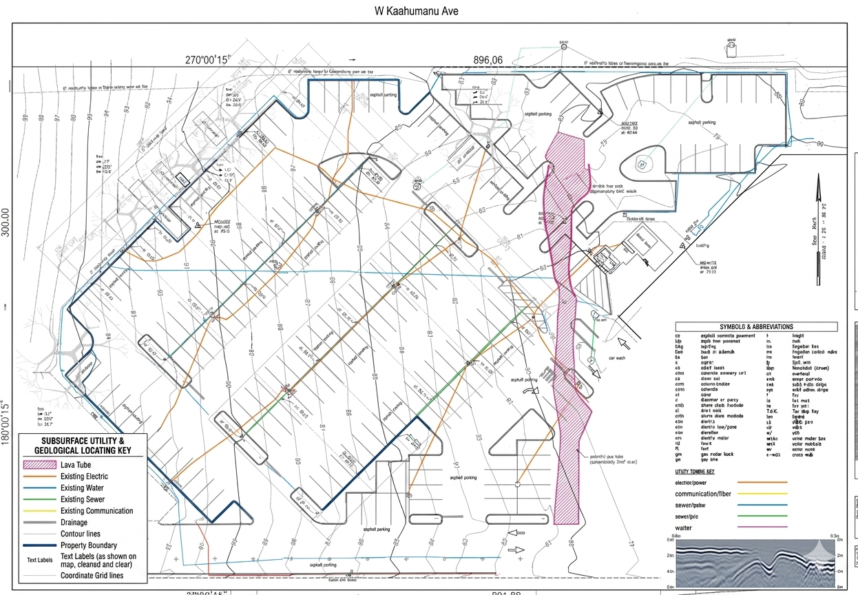
Subsurface Utility and Geological Locating Map
Below is the locating map we produced from the site. It displays existing utilities, property boundaries, and the identified lava tube. The pink hatched zone indicates the corridor identified via GPR at approximately 9 feet depth.
What the Map Shows
The map documents electric lines (orange), water mains (blue), and sewer infrastructure (teal). Additionally, you can see communication lines (yellow) and drainage (grey). The lava tube corridor is shown in the pink hatched zone, running diagonally through the eastern portion of the parking area.
Specialized GPR for Lava Tube Detection on Maui
GPR works by transmitting radio waves into the ground and recording reflections. Voids produce a strong, distinctive signature because the air inside the tube creates a sharp contrast with the surrounding basalt.
On Maui, GPR operators must understand that volcanic geology creates conditions unlike mainland soil. Basalt layers and complex stratigraphy affect how signals travel. Therefore, local experience with Hawaii's terrain is not interchangeable with mainland locating experience.
Project Outcome
We documented the discovery, included it in the final report, and alerted the project team. Any future excavation in this zone must account for the structural risk. This discovery highlights exactly why professional scanning is vital — conventional records simply cannot see what lies 9 feet down.
IMI Systems Field Note
We completed this locate as part of a standard clearance. However, our commitment to full-coverage scanning made this identification possible. IMI Systems documents all significant subsurface features, ensuring our clients stay safe and informed.
Frequently Asked Questions
How common are lava tubes beneath Maui properties?
They are more common than most owners expect. Most go unnoticed because the ground above them is never systematically scanned.
Can a lava tube cause surface collapse?
Yes. A void 9 feet down represents a genuine risk depending on the tube size and the weight of the loads applied at the surface.
Does 811 identify lava tubes?
No. 811 only marks registered public utilities. It has no capability to detect geological features or voids.
Can IMI Systems scan my property?
Yes. We offer GPR scanning for voids as part of our standard investigation services. Contact us today for a lava tube detection Maui consultation.
Planning excavation on a Maui property?
IMI Systems provides GPR scanning for utilities, cesspools, and geological features including lava tube voids. Based in Paia — available across all of Maui within 48 hours. Schedule a GPR Scan